The starting point is the parking area of San Marco and, from here, we take the paved road heading towards Monte Pacciano. At the first fork, we take a dirt track that ascends straight to the Church of San Orfeto, in a panoramic position. We continue on Strada dei Conservoni and then take Strada della Perotta. The hillsides around Perugia are visible on the right. The road ends beyond an enormous farmhouse in a charming position, and a short time later we take the first path that leads to the summit of Monte Pacciano (648 m). We cross through a rather broad, wild and barren area that, just before we get to the woods, rejoins a dirt road.
At this point on our walk, the landscape opens up before us with a view of the Apennines, the Tiber valley, Assisi and Monte Subasio, and Perugia. We turn right towards Montenero, Montebagnolo and Montelaguardia, and enter into mixed woods with conifers and deciduous oaks. We then continue on the paved road linking Montelaguardia, Montebagnolo and Valbiancara. We turn left, heading towards Valbiancara and Migiana, and the impressive outline of the massif of Monte Tezio is visible in the foreground. The setting gradually shifts from fields dotted with farmhouses to woods with numerous tree species, such as turkey oaks, downy oaks, hornbeams, maples, arbutuses and chestnuts, and we take several tracks – carefully following the signs – until we reach the built-up area of San Lorenzo della Rabatta. At the fork in the road close to the little hamlet, we head left towards the cemetery and then ascend to a dale next to Monte Pacciano. We continue downhill to a rather wide unpaved road that skirts the woods. At this point, we have two options in order to complete our circuit.
While they go through two different segments of the woods, both go past the old water reservoirs of the Municipality of Perugia and the area is well worth a stop. The woods we cross are striking and, proceeding directly downhill, we come to the paved road. From here, we retrace our steps on the road that takes us back to our starting point.
The total length of the itinerary is 11.890 km.
 FILE GPX
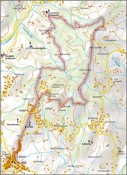 FILE MAP


